Mezzolombardo night lights from space
Night Light of Mezzolombardo (Trentino-Alto Adige) from space (Italy) Src. Average luminocity for 10x10km area is 22.0511% and for 50x50km: 9.4594%.
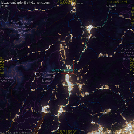
Analysis of Mezzolombardo night lights 2016
Square area 10x10 km:
 1.99%
1.99%90-99
4.12%80-89
2.27%70-79
1.42%60-69
2.84%50-59
2.27%40-49
1.56%30-39
1.99%20-29
6.68%10-19
35.09%0-9
39.77%Square area 50x50 km:
1.06%90-99
1.36%80-89
0.64%70-79
1.15%60-69
1.13%50-59
1.24%40-49
1.44%30-39
1.49%20-29
2.91%10-19
8.54%0-9
79.04%Clear (daylight) street map image can be seen on geolist.org.
Map coordinates:
46° 41' 31.8" North, 10° 23' 35.7" East
46° 12' 27.9" North, 11° 5' 46.9" East
45° 43' 8.4" North, 11° 47' 58.2" East
Some cities around Mezzolombardo sort by population:
• Trento
15.7 km =9.8 mi,  173°
173°
• Pergine Valsugana
19.3 km =12 mi,  145°
145°
• Lavis
7.5 km =4.7 mi, 172°
• Caldaro sulla Strada del Vino
25.6 km =15.9 mi,  26°
26°
• Levico Terme
27 km =16.8 mi,  143°
143°
• San Michele
30.3 km =18.8 mi,  24°
24°
• Cles
17.9 km =11.1 mi,  344°
344°
• Mattarello
22.3 km =13.9 mi, 173°
3173480 (p: 6,754)
Sources (retrieved 2019-11-25):
» Earth at Night: Flat Maps 2012, 2016