Gorle night lights from space
Night Light of Gorle (Lombardy) from space (Italy) Src. Average luminocity for 10x10km area is 86.2242% and for 50x50km: 47.3941%.
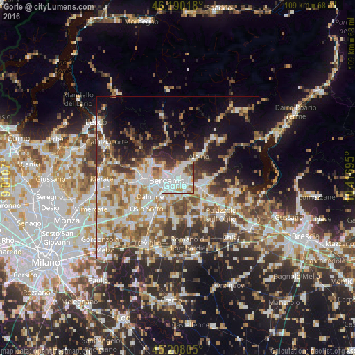
Analysis of Gorle night lights 2016
Square area 10x10 km:
 40.91%
90-99
26.21%80-89
5.76%70-79
5.45%60-69
4.85%50-59
6.82%40-49
4.39%30-39
5.61%20-29
0%10-19
0%0-9
0%Square area 50x50 km:
9.92%90-99
10.74%80-89
4.58%70-79
5.51%60-69
7.11%50-59
7.6%40-49
7.09%30-39
7.97%20-29
8.99%10-19
10.94%0-9
19.55%Clear (daylight) street map image can be seen on geolist.org.
Map coordinates:
46° 11' 24.6" North, 9° 0' 38.5" East
45° 42' 4.6" North, 9° 42' 49.8" East
45° 12' 29" North, 10° 25' 1" East
Some cities around Gorle sort by population:
• Bergamo
3.7 km =2.3 mi,  260°
260°
• Seriate
2 km =1.2 mi,  154°
154°
• Alzano Lombardo
4.1 km =2.5 mi,  13°
13°
• Torre Boldone
1.8 km =1.1 mi,  345°
345°
• Villa di Serio
2.9 km =1.8 mi,  35°
35°
• Scanzo-Rosciate
2 km =1.2 mi,  57°
57°
• Ranica
2.4 km =1.5 mi,  359°
359°
• Pedrengo
1.7 km =1.1 mi,  109°
109°
3175983 (p: 6,441)
Sources (retrieved 2019-11-25):
» Earth at Night: Flat Maps 2012, 2016