Treviolo night lights from space
Night Light of Treviolo (Lombardy) from space (Italy) Src. Average luminocity for 10x10km area is 90.7333% and for 50x50km: 54.7002%.
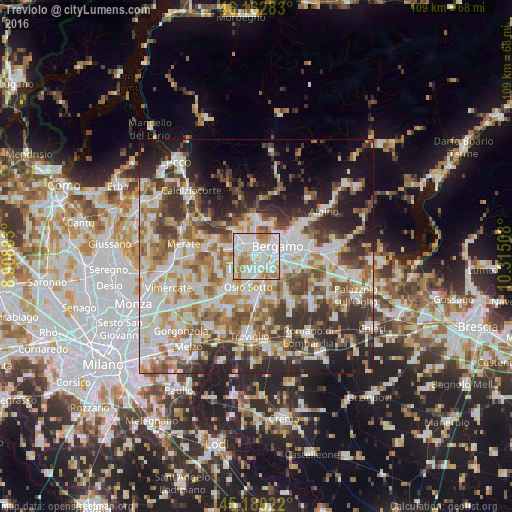
Analysis of Treviolo night lights 2016
Square area 10x10 km:
 37.58%
90-99
32.42%80-89
5.45%70-79
10.76%60-69
12.88%50-59
0.91%40-49
0%30-39
0%20-29
0%10-19
0%0-9
0%Square area 50x50 km:
12.66%90-99
13.43%80-89
5.32%70-79
6.54%60-69
7.98%50-59
7.56%40-49
7%30-39
8.18%20-29
10.55%10-19
11.03%0-9
9.76%Clear (daylight) street map image can be seen on geolist.org.
Map coordinates:
46° 9' 46.2" North, 8° 54' 31.8" East
45° 40' 25.2" North, 9° 36' 43" East
45° 10' 48.8" North, 10° 18' 54.3" East
Some cities around Treviolo sort by population:
• Bergamo
5 km =3.1 mi,  59°
59°
• Dalmine
2.7 km =1.7 mi,  189°
189°
• Stezzano
4.1 km =2.5 mi,  130°
130°
• Ponte San Pietro
4 km =2.5 mi,  335°
335°
• Curno
1.7 km =1.1 mi,  351°
351°
• Mozzo
2.8 km =1.7 mi, 354°
• Bonate Sopra
4.2 km =2.6 mi,  282°
282°
• Bonate Sotto
4.2 km =2.6 mi,  261°
261°
6534248 (p: 9,266)
Sources (retrieved 2019-11-25):
» Earth at Night: Flat Maps 2012, 2016