Pāsārgād night lights from space
Night Light of Pāsārgād (Fars) from space (Iran) Src. Average luminocity for 10x10km area is 7.451% and for 50x50km: 3.6093%.
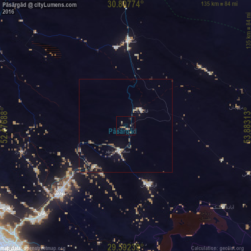

Analysis of Pāsārgād night lights 2016
Square area 10x10 km:
 0%
0%90-99
0.7%80-89
1.4%70-79
1.4%60-69
1.05%50-59
2.45%40-49
0.52%30-39
0.87%20-29
1.4%10-19
1.4%0-9
88.81%Square area 50x50 km:
0.21%90-99
0.43%80-89
0.37%70-79
0.27%60-69
0.43%50-59
0.76%40-49
0.76%30-39
0.7%20-29
0.6%10-19
2.34%0-9
93.11%Clear (daylight) street map image can be seen on geolist.org.
Map coordinates:
30° 48' 27.9" North, 52° 28' 36.8" East
30° 12' 7" North, 53° 10' 48" East
29° 35' 32.6" North, 53° 52' 59.3" East
Some cities around Pāsārgād sort by population:
• Shiraz
90.8 km =56.4 mi,  223°
223°
• Marvdasht
51.5 km =32 mi, 224°
• Akbarābād
113.1 km =70.3 mi,  200°
200°
• Fasā
147.6 km =91.7 mi,  162°
162°
• Kāzerūn
160.8 km =99.9 mi,  246°
246°
• Nūrābād
159.7 km =99.2 mi,  266°
266°
• Ābādeh
118 km =73.3 mi,  334°
334°
• Neyrīz
157.3 km =97.7 mi,  135°
135°
401202 (p: 29,825)
Sources (retrieved 2019-11-25):
» Earth at Night: Flat Maps 2012, 2016