Pādegān-e Manjīl night lights from space
Night Light of Pādegān-e Manjīl (Gīlān) from space (Iran) Src. Average luminocity for 10x10km area is 17.2413% and for 50x50km: 3.0173%.
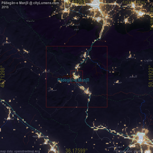
Analysis of Pādegān-e Manjīl night lights 2016
Square area 10x10 km:
 0%
0%90-99
0%80-89
0.87%70-79
9.62%60-69
1.22%50-59
2.27%40-49
2.8%30-39
0.7%20-29
2.62%10-19
12.59%0-9
67.31%Square area 50x50 km:
0.06%90-99
0.08%80-89
0.12%70-79
1.09%60-69
0.39%50-59
0.5%40-49
0.61%30-39
0.55%20-29
0.55%10-19
1.4%0-9
94.65%Clear (daylight) street map image can be seen on geolist.org.
Map coordinates:
37° 18' 10.3" North, 48° 42' 46.7" East
36° 44' 29.4" North, 49° 24' 58" East
36° 10' 33.6" North, 50° 7' 9.2" East
Some cities around Pādegān-e Manjīl sort by population:
• Rasht
61.4 km =38.2 mi,  14°
14°
• Qazvin
74.3 km =46.2 mi,  135°
135°
• Alvand
52 km =32.3 mi,  205°
205°
• Tākestān
78.7 km =48.9 mi,  161°
161°
• Abhar
68.5 km =42.6 mi,  195°
195°
• Khorramdarreh
62.5 km =38.8 mi, 198°
• Āstāneh-ye Ashrafīyeh
74.5 km =46.3 mi,  38°
38°
• Fūman
54.4 km =33.8 mi,  350°
350°
41428 (p: 17,396)
Sources (retrieved 2019-11-25):
» Earth at Night: Flat Maps 2012, 2016