Sālūmbar night lights from space
Night Light of Sālūmbar (Rajasthan) from space (India) Src. Average luminocity for 10x10km area is 6.5777% and for 50x50km: 0.6234%.
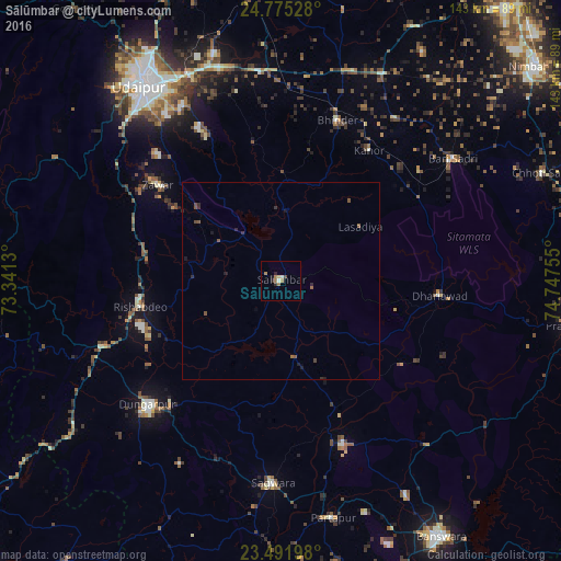
Analysis of Sālūmbar night lights 2016
Square area 10x10 km:
 0%
0%90-99
1.52%80-89
0.76%70-79
0%60-69
3.79%50-59
0%40-49
0.76%30-39
0%20-29
1.89%10-19
1.14%0-9
90.15%Square area 50x50 km:
0%90-99
0.06%80-89
0.03%70-79
0%60-69
0.2%50-59
0.2%40-49
0.17%30-39
0.09%20-29
0.24%10-19
0.24%0-9
98.76%Clear (daylight) street map image can be seen on geolist.org.
Map coordinates:
24° 46' 31" North, 73° 20' 28.7" East
24° 8' 6.9" North, 74° 2' 39.9" East
23° 29' 31.1" North, 74° 44' 51.2" East
Some cities around Sālūmbar sort by population:
• Udaipur
60.3 km =37.5 mi,  326°
326°
• Dūngarpur
46.7 km =29 mi,  225°
225°
• Chhoti Sādri
72 km =44.7 mi,  67°
67°
• Bhindār
43.2 km =26.8 mi,  19°
19°
• Bari Sādri
53.4 km =33.2 mi,  54°
54°
• Kānor
40.1 km =24.9 mi,  33°
33°
• Partāpur
61.7 km =38.3 mi,  167°
167°
• Galiākot
68.5 km =42.6 mi,  182°
182°
1257588 (p: 16,557)
Sources (retrieved 2019-11-25):
» Earth at Night: Flat Maps 2012, 2016