Bhindār night lights from space
Night Light of Bhindār (Rajasthan) from space (India) Src. Average luminocity for 10x10km area is 8.5139% and for 50x50km: 5.0327%.
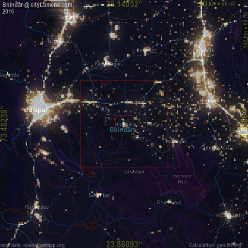
Analysis of Bhindār night lights 2016
Square area 10x10 km:
 0%
0%90-99
1.59%80-89
0%70-79
0.79%60-69
1.59%50-59
1.19%40-49
1.19%30-39
3.17%20-29
3.17%10-19
0%0-9
87.3%Square area 50x50 km:
0.02%90-99
0.38%80-89
0.29%70-79
0.44%60-69
0.52%50-59
1.12%40-49
1.51%30-39
1.47%20-29
1.81%10-19
1.45%0-9
90.99%Clear (daylight) street map image can be seen on geolist.org.
Map coordinates:
25° 8' 25.9" North, 73° 28' 56.6" East
24° 30' 8.5" North, 74° 11' 7.8" East
23° 51' 39.3" North, 74° 53' 19.1" East
Some cities around Bhindār sort by population:
• Udaipur
48.6 km =30.2 mi,  281°
281°
• Chittaurgarh
61.8 km =38.4 mi,  45°
45°
• Nīmbāhera
51.7 km =32.1 mi,  75°
75°
• Nāthdwāra
60.7 km =37.7 mi,  322°
322°
• Chhoti Sādri
53.9 km =33.5 mi,  104°
104°
• Sālūmbar
43.2 km =26.8 mi,  199°
199°
• Bari Sādri
30.8 km =19.1 mi,  108°
108°
• Kānor
11.1 km =6.9 mi,  133°
133°
1275925 (p: 16,945)
Sources (retrieved 2019-11-25):
» Earth at Night: Flat Maps 2012, 2016