Chhoti Sādri night lights from space
Night Light of Chhoti Sādri (Rajasthan) from space (India) Src. Average luminocity for 10x10km area is 13.371% and for 50x50km: 11.1541%.
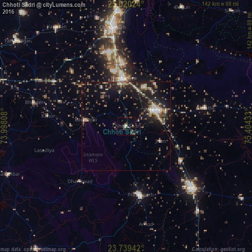
Analysis of Chhoti Sādri night lights 2016
Square area 10x10 km:
 0.4%
0.4%90-99
1.19%80-89
2.38%70-79
1.19%60-69
0.4%50-59
2.58%40-49
2.98%30-39
4.76%20-29
2.38%10-19
3.97%0-9
77.78%Square area 50x50 km:
0.44%90-99
1.7%80-89
0.97%70-79
0.91%60-69
1.48%50-59
2.21%40-49
2.19%30-39
2.61%20-29
4.21%10-19
9.14%0-9
74.15%Clear (daylight) street map image can be seen on geolist.org.
Map coordinates:
25° 1' 12.9" North, 73° 59' 53.1" East
24° 22' 53.2" North, 74° 42' 4.3" East
23° 44' 21.9" North, 75° 24' 15.6" East
Some cities around Chhoti Sādri sort by population:
• Nīmbāhera
26.8 km =16.7 mi,  355°
355°
• Pratāpgarh
39.7 km =24.7 mi,  168°
168°
• Jāwad
29.2 km =18.1 mi,  34°
34°
• Bari Sādri
23.3 km =14.5 mi,  278°
278°
• Kānor
44.5 km =27.7 mi, 277°
• Jīran
20.8 km =12.9 mi,  112°
112°
• Nārāyangarh
37.4 km =23.2 mi, 109°
• Malhārgarh
31.3 km =19.4 mi, 110°
1274284 (p: 17,335)
Sources (retrieved 2019-11-25):
» Earth at Night: Flat Maps 2012, 2016