Periyapatti night lights from space
Night Light of Periyapatti (Tamil Nadu) from space (India) Src. Average luminocity for 10x10km area is 1.6983% and for 50x50km: 8.0424%.
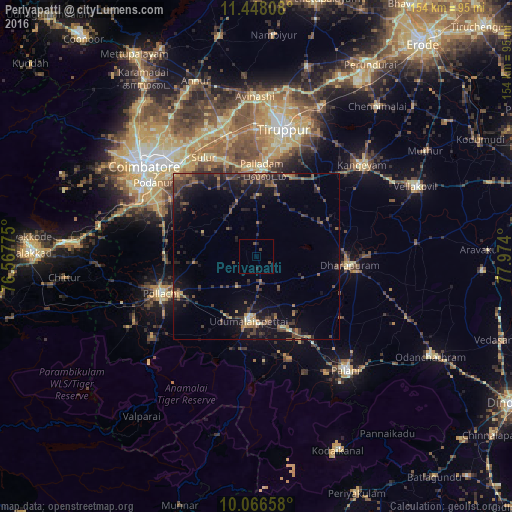
Analysis of Periyapatti night lights 2016
Square area 10x10 km:
 0%
0%90-99
0%80-89
0%70-79
0%60-69
0%50-59
0%40-49
1.86%30-39
0.62%20-29
1.65%10-19
0%0-9
95.87%Square area 50x50 km:
0.03%90-99
0.31%80-89
0.4%70-79
0.75%60-69
1.2%50-59
1.5%40-49
2.8%30-39
2.76%20-29
3.34%10-19
8.28%0-9
78.63%Clear (daylight) street map image can be seen on geolist.org.
Map coordinates:
11° 26' 53.1" North, 76° 34' 3.9" East
10° 45' 29.2" North, 77° 16' 15.1" East
10° 3' 59.7" North, 77° 58' 26.4" East
Some cities around Periyapatti sort by population:
• Pollachi
30.7 km =19.1 mi,  248°
248°
• Dharapuram
28.6 km =17.8 mi,  94°
94°
• Udumalaippettai
19.1 km =11.9 mi,  187°
187°
• Palladam
26 km =16.2 mi,  3°
3°
• Chettipālaiyam
30.8 km =19.1 mi,  303°
303°
• Kumaralingam
31.1 km =19.3 mi,  163°
163°
• Dhali
29 km =18 mi,  198°
198°
• Kīranūr
31.3 km =19.4 mi,  125°
125°
1259875 (p: 10,647)
Sources (retrieved 2019-11-25):
» Earth at Night: Flat Maps 2012, 2016