Kīranūr night lights from space
Night Light of Kīranūr (Tamil Nadu) from space (India) Src. Average luminocity for 10x10km area is 1.219% and for 50x50km: 5.8901%.
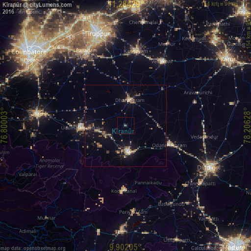
Analysis of Kīranūr night lights 2016
Square area 10x10 km:
 0%
0%90-99
0%80-89
0%70-79
0%60-69
0.41%50-59
0.41%40-49
0.41%30-39
0.41%20-29
0%10-19
0.83%0-9
97.52%Square area 50x50 km:
0.1%90-99
0.38%80-89
0.58%70-79
0.77%60-69
0.72%50-59
0.9%40-49
1.65%30-39
1.64%20-29
1.52%10-19
4.52%0-9
87.23%Clear (daylight) street map image can be seen on geolist.org.
Map coordinates:
11° 17' 3.4" North, 76° 48' 0.1" East
10° 35' 38.2" North, 77° 30' 11.3" East
9° 54' 7.4" North, 78° 12' 22.6" East
Some cities around Kīranūr sort by population:
• Dharapuram
16.4 km =10.2 mi,  11°
11°
• Palani
16.1 km =10 mi,  173°
173°
• Udumalaippettai
27.9 km =17.3 mi,  268°
268°
• Ayakudi
16.9 km =10.5 mi,  161°
161°
• Mūlanūr
31.8 km =19.8 mi,  45°
45°
• Kumaralingam
20.4 km =12.7 mi,  235°
235°
• Periyapatti
31.3 km =19.4 mi,  305°
305°
• Dhali
35.7 km =22.2 mi,  254°
254°
1266512 (p: 6,487)
Sources (retrieved 2019-11-25):
» Earth at Night: Flat Maps 2012, 2016