Kumaralingam night lights from space
Night Light of Kumaralingam (Tamil Nadu) from space (India) Src. Average luminocity for 10x10km area is 10.6467% and for 50x50km: 6.0216%.
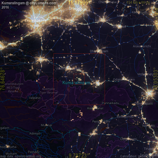
Analysis of Kumaralingam night lights 2016
Square area 10x10 km:
 0%
0%90-99
0%80-89
1.03%70-79
3.1%60-69
0.83%50-59
1.24%40-49
2.89%30-39
2.48%20-29
1.45%10-19
5.79%0-9
81.2%Square area 50x50 km:
0.12%90-99
0.55%80-89
0.54%70-79
0.96%60-69
0.68%50-59
0.74%40-49
1.5%30-39
1.63%20-29
1.33%10-19
5.5%0-9
86.46%Clear (daylight) street map image can be seen on geolist.org.
Map coordinates:
11° 10' 47.8" North, 76° 38' 48.4" East
10° 29' 21.7" North, 77° 20' 59.6" East
9° 47' 50" North, 78° 3' 10.9" East
Some cities around Kumaralingam sort by population:
• Palani
19.2 km =11.9 mi,  103°
103°
• Udumalaippettai
15.7 km =9.8 mi,  314°
314°
• Kodaikānāl
31.7 km =19.7 mi,  151°
151°
• Marayur
31.3 km =19.4 mi,  220°
220°
• Ayakudi
22.5 km =14 mi, 101°
• Periyapatti
31.1 km =19.3 mi,  343°
343°
• Dhali
17.8 km =11.1 mi,  277°
277°
• Kīranūr
20.4 km =12.7 mi,  55°
55°
1265697 (p: 12,093)
Sources (retrieved 2019-11-25):
» Earth at Night: Flat Maps 2012, 2016