Dhali night lights from space
Night Light of Dhali (Tamil Nadu) from space (India) Src. Average luminocity for 10x10km area is 1.9979% and for 50x50km: 6.5096%.
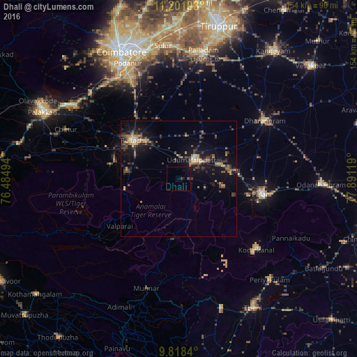
Analysis of Dhali night lights 2016
Square area 10x10 km:
 0%
0%90-99
0%80-89
0%70-79
0%60-69
0%50-59
0%40-49
0.83%30-39
1.24%20-29
0.21%10-19
1.86%0-9
95.87%Square area 50x50 km:
0.08%90-99
0.37%80-89
0.77%70-79
1.13%60-69
0.93%50-59
0.7%40-49
1.75%30-39
1.87%20-29
1.76%10-19
6.12%0-9
84.54%Clear (daylight) street map image can be seen on geolist.org.
Map coordinates:
11° 12' 3.7" North, 76° 29' 5.8" East
10° 30' 37.8" North, 77° 11' 17" East
9° 49' 6.2" North, 77° 53' 28.3" East
Some cities around Dhali sort by population:
• Pollachi
25.6 km =15.9 mi,  309°
309°
• Udumalaippettai
10.8 km =6.7 mi,  37°
37°
• Marayur
26.2 km =16.3 mi,  186°
186°
• Vettaikkaranpudur
30.6 km =19 mi,  280°
280°
• Anamalais
28.9 km =18 mi,  286°
286°
• Kumaralingam
17.8 km =11.1 mi,  97°
97°
• Periyapatti
29 km =18 mi,  18°
18°
• Periyanegamam
27.5 km =17.1 mi,  340°
340°
1273033 (p: 6,494)
Sources (retrieved 2019-11-25):
» Earth at Night: Flat Maps 2012, 2016