Pātan night lights from space
Night Light of Pātan (Chhattisgarh) from space (India) Src. Average luminocity for 10x10km area is 15.9742% and for 50x50km: 32.0024%.
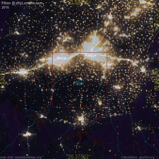
Analysis of Pātan night lights 2016
Square area 10x10 km:
 0.79%
0.79%90-99
0.79%80-89
0.79%70-79
0.4%60-69
1.98%50-59
3.57%40-49
5.16%30-39
5.95%20-29
4.56%10-19
8.93%0-9
67.06%Square area 50x50 km:
9.7%90-99
5.37%80-89
2.4%70-79
2.5%60-69
4.18%50-59
5.16%40-49
5.61%30-39
4.4%20-29
5.78%10-19
9.05%0-9
45.86%Clear (daylight) street map image can be seen on geolist.org.
Map coordinates:
21° 41' 17.3" North, 80° 49' 48.8" East
21° 1' 60" North, 81° 31' 60" East
20° 22' 32.2" North, 82° 14' 11.3" East
Some cities around Pātan sort by population:
• Raipur
24.5 km =15.2 mi,  25°
25°
• Bhilai
22.4 km =13.9 mi,  330°
330°
• Durg
31.9 km =19.8 mi,  303°
303°
• Dhamtari
36.3 km =22.6 mi,  177°
177°
• Kumhāri
26 km =16.2 mi,  356°
356°
• Balod
47.8 km =29.7 mi,  225°
225°
• Kurud
29.9 km =18.6 mi,  138°
138°
• Bhatgaon
21.6 km =13.4 mi,  53°
53°
1260176 (p: 9,332)
Sources (retrieved 2019-11-25):
» Earth at Night: Flat Maps 2012, 2016