Bhatgaon night lights from space
Night Light of Bhatgaon (Chhattisgarh) from space (India) Src. Average luminocity for 10x10km area is 61.8294% and for 50x50km: 42.9109%.
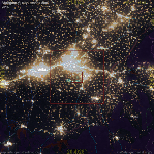
Analysis of Bhatgaon night lights 2016
Square area 10x10 km:
 7.14%
7.14%90-99
10.71%80-89
6.75%70-79
9.13%60-69
15.08%50-59
18.45%40-49
14.88%30-39
10.32%20-29
7.34%10-19
0.2%0-9
0%Square area 50x50 km:
10%90-99
7.73%80-89
3.81%70-79
4.52%60-69
6.03%50-59
7.42%40-49
7.64%30-39
6.44%20-29
8.84%10-19
17.59%0-9
19.98%Clear (daylight) street map image can be seen on geolist.org.
Map coordinates:
21° 48' 15.5" North, 80° 59' 48.8" East
21° 9' 0" North, 81° 42' 0" East
20° 29' 34.1" North, 82° 24' 11.3" East
Some cities around Bhatgaon sort by population:
• Raipur
11.6 km =7.2 mi,  323°
323°
• Bhilai
28.9 km =18 mi,  283°
283°
• Durg
44.2 km =27.5 mi, 275°
• Mahāsamund
41.2 km =25.6 mi,  96°
96°
• Kumhāri
23 km =14.3 mi,  304°
304°
• Arang
28.4 km =17.6 mi,  79°
79°
• Kurud
35.6 km =22.1 mi,  176°
176°
• Pātan
21.6 km =13.4 mi,  233°
233°
1276079 (p: 8,044)
Sources (retrieved 2019-11-25):
» Earth at Night: Flat Maps 2012, 2016