Kurud night lights from space
Night Light of Kurud (Chhattisgarh) from space (India) Src. Average luminocity for 10x10km area is 23.7183% and for 50x50km: 12.2713%.
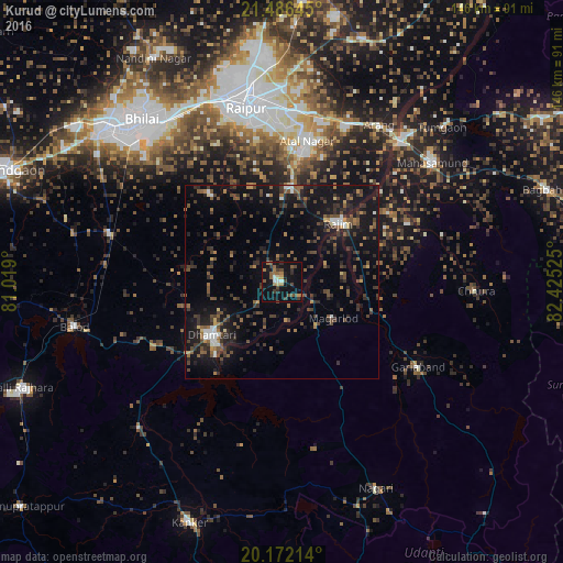
Analysis of Kurud night lights 2016
Square area 10x10 km:
 0.79%
0.79%90-99
2.38%80-89
1.79%70-79
1.98%60-69
3.97%50-59
6.94%40-49
4.56%30-39
6.55%20-29
2.98%10-19
30.75%0-9
37.3%Square area 50x50 km:
0.71%90-99
0.77%80-89
0.52%70-79
0.73%60-69
1.35%50-59
2.85%40-49
3.37%30-39
3.85%20-29
4.02%10-19
13.07%0-9
68.76%Clear (daylight) street map image can be seen on geolist.org.
Map coordinates:
21° 29' 11.2" North, 81° 1' 8.4" East
20° 49' 50.6" North, 81° 43' 19.6" East
20° 10' 19.7" North, 82° 25' 30.9" East
Some cities around Kurud sort by population:
• Raipur
45.7 km =28.4 mi,  348°
348°
• Dhamtari
22.7 km =14.1 mi,  232°
232°
• Mahāsamund
49.4 km =30.7 mi,  51°
51°
• Arang
48.1 km =29.9 mi,  32°
32°
• Gariāband
41.6 km =25.8 mi,  121°
121°
• Pātan
29.9 km =18.6 mi,  318°
318°
• Bhatgaon
35.6 km =22.1 mi,  356°
356°
• Narharpur
43.8 km =27.2 mi,  194°
194°
1265472 (p: 11,290)
Sources (retrieved 2019-11-25):
» Earth at Night: Flat Maps 2012, 2016