Pallattūr night lights from space
Night Light of Pallattūr (Tamil Nadu) from space (India) Src. Average luminocity for 10x10km area is 10.2913% and for 50x50km: 4.2892%.
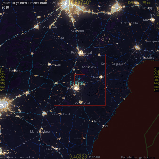
Analysis of Pallattūr night lights 2016
Square area 10x10 km:
 0%
0%90-99
0%80-89
0.62%70-79
0.62%60-69
0.41%50-59
3.93%40-49
4.34%30-39
2.48%20-29
1.45%10-19
15.7%0-9
70.45%Square area 50x50 km:
0.04%90-99
0.26%80-89
0.69%70-79
0.81%60-69
0.47%50-59
0.74%40-49
1.04%30-39
0.81%20-29
1.12%10-19
3.04%0-9
90.98%Clear (daylight) street map image can be seen on geolist.org.
Map coordinates:
10° 50' 14.9" North, 78° 5' 59.9" East
10° 8' 45.9" North, 78° 48' 11.1" East
9° 27' 11.6" North, 79° 30' 22.4" East
Some cities around Pallattūr sort by population:
• Pudukkottai
26.2 km =16.3 mi,  4°
4°
• Kāraikkudi
9.7 km =6 mi,  203°
203°
• Devakottai
22.2 km =13.8 mi,  174°
174°
• Arantāngi
20.8 km =12.9 mi,  81°
81°
• Ponnamarāvati
32.8 km =20.4 mi,  297°
297°
• Kottaiyūr
4.1 km =2.5 mi,  191°
191°
• Ālangudi
31.1 km =19.3 mi,  39°
39°
• Arimalam
15 km =9.3 mi, 36°
1260693 (p: 8,186)
Sources (retrieved 2019-11-25):
» Earth at Night: Flat Maps 2012, 2016