Arimalam night lights from space
Night Light of Arimalam (Tamil Nadu) from space (India) Src. Average luminocity for 10x10km area is 0.438% and for 50x50km: 4.5497%.
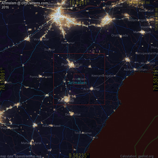
Analysis of Arimalam night lights 2016
Square area 10x10 km:
 0%
0%90-99
0%80-89
0%70-79
0%60-69
0%50-59
0%40-49
0%30-39
0.41%20-29
1.24%10-19
0%0-9
98.35%Square area 50x50 km:
0.04%90-99
0.43%80-89
0.82%70-79
0.78%60-69
0.36%50-59
0.67%40-49
1.12%30-39
0.85%20-29
1.02%10-19
4.06%0-9
89.84%Clear (daylight) street map image can be seen on geolist.org.
Map coordinates:
10° 56' 46" North, 78° 10' 51.3" East
10° 15' 17.9" North, 78° 53' 2.5" East
9° 33' 44.5" North, 79° 35' 13.8" East
Some cities around Arimalam sort by population:
• Pudukkottai
15.6 km =9.7 mi,  333°
333°
• Kāraikkudi
24.5 km =15.2 mi,  211°
211°
• Devakottai
34.9 km =21.7 mi,  190°
190°
• Arantāngi
14.9 km =9.3 mi,  128°
128°
• Kottaiyūr
18.8 km =11.7 mi, 210°
• Ālangudi
16.1 km =10 mi,  43°
43°
• Pallattūr
15 km =9.3 mi,  216°
216°
• Annavāsal
30.4 km =18.9 mi,  318°
318°
1278409 (p: 8,048)
Sources (retrieved 2019-11-25):
» Earth at Night: Flat Maps 2012, 2016