Ponnamarāvati night lights from space
Night Light of Ponnamarāvati (Tamil Nadu) from space (India) Src. Average luminocity for 10x10km area is 6.2934% and for 50x50km: 1.8632%.
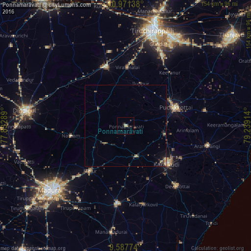
Analysis of Ponnamarāvati night lights 2016
Square area 10x10 km:
 0%
0%90-99
1.65%80-89
0%70-79
0.83%60-69
1.65%50-59
0%40-49
1.24%30-39
2.69%20-29
2.48%10-19
0.21%0-9
89.26%Square area 50x50 km:
0.01%90-99
0.13%80-89
0.29%70-79
0.22%60-69
0.26%50-59
0.19%40-49
0.37%30-39
0.75%20-29
0.71%10-19
0.85%0-9
96.21%Clear (daylight) street map image can be seen on geolist.org.
Map coordinates:
10° 58' 17" North, 77° 49' 58.4" East
10° 16' 49.2" North, 78° 32' 9.6" East
9° 35' 15.9" North, 79° 14' 20.9" East
Some cities around Ponnamarāvati sort by population:
• Pudukkottai
33.2 km =20.6 mi,  70°
70°
• Kāraikkudi
34.8 km =21.6 mi,  133°
133°
• Melur
35 km =21.7 mi,  217°
217°
• Nattam
34 km =21.1 mi,  260°
260°
• Iluppūr
27.6 km =17.1 mi,  20°
20°
• Kottaiyūr
34.2 km =21.3 mi,  123°
123°
• Pallattūr
32.8 km =20.4 mi, 117°
• Annavāsal
26.9 km =16.7 mi,  41°
41°
1259413 (p: 11,741)
Sources (retrieved 2019-11-25):
» Earth at Night: Flat Maps 2012, 2016