Niwāri night lights from space
Night Light of Niwāri (Uttar Pradesh) from space (India) Src. Average luminocity for 10x10km area is 52.3996% and for 50x50km: 56.529%.
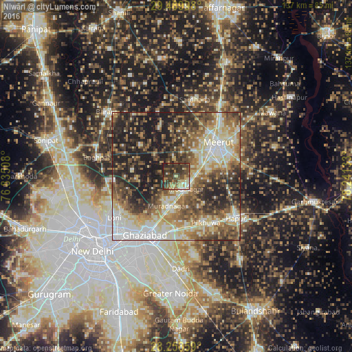
Analysis of Niwāri night lights 2016
Square area 10x10 km:
 2.08%
2.08%90-99
5.49%80-89
10.61%70-79
6.25%60-69
8.33%50-59
11.74%40-49
18.37%30-39
24.62%20-29
12.5%10-19
0%0-9
0%Square area 50x50 km:
8.31%90-99
11.15%80-89
10.6%70-79
5.85%60-69
8.74%50-59
10.55%40-49
10.57%30-39
9.59%20-29
12.15%10-19
12.49%0-9
0.01%Clear (daylight) street map image can be seen on geolist.org.
Map coordinates:
29° 29' 23.9" North, 76° 50' 6.3" East
28° 52' 34" North, 77° 32' 17.5" East
28° 15' 30.9" North, 78° 14' 28.8" East
Some cities around Niwāri sort by population:
• Meerut
20 km =12.4 mi,  54°
54°
• Ghāziābād
25.3 km =15.7 mi,  202°
202°
• Murādnagar
11.3 km =7 mi, 199°
• Pilkhua
21.5 km =13.4 mi,  147°
147°
• Khekra
24.8 km =15.4 mi,  267°
267°
• Dāsna
22.2 km =13.8 mi,  183°
183°
• Kharkhauda
20.3 km =12.6 mi,  102°
102°
• Farīdnagar
14.8 km =9.2 mi,  143°
143°
1261262 (p: 10,330)
Sources (retrieved 2019-11-25):
» Earth at Night: Flat Maps 2012, 2016