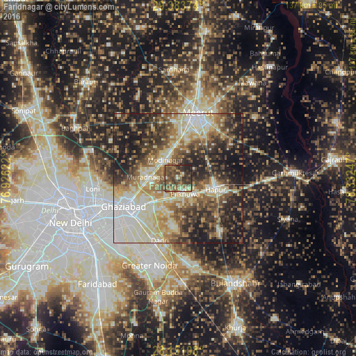
Farīdnagar night lights from space
Night Light of Farīdnagar (Uttar Pradesh) from space (India) Src. Average luminocity for 10x10km area is 51.1629% and for 50x50km: 56.4915%.
Analysis of Farīdnagar night lights 2016
Square area 10x10 km:
 0.57%
0.57%90-99
5.68%80-89
6.06%70-79
3.41%60-69
10.98%50-59
21.4%40-49
21.59%30-39
18.18%20-29
9.85%10-19
2.27%0-9
0%Square area 50x50 km:
8.46%90-99
11.85%80-89
11.04%70-79
5.92%60-69
8.44%50-59
9.18%40-49
9.97%30-39
9.4%20-29
11.36%10-19
13.61%0-9
0.76%Clear (daylight) street map image can be seen on geolist.org.
Map coordinates:
29° 23' 1.5" North, 76° 55' 34.4" East
28° 46' 9.2" North, 77° 37' 45.6" East
28° 9' 3.9" North, 78° 19' 56.9" East
Some cities around Farīdnagar sort by population:
• Ghāziābād
21.8 km =13.5 mi,  238°
238°
• Hāpur
15.4 km =9.6 mi,  106°
106°
• Murādnagar
12.8 km =8 mi,  275°
275°
• Pilkhua
6.8 km =4.2 mi,  157°
157°
• Dāsna
14.6 km =9.1 mi,  225°
225°
• Kharkhauda
13.2 km =8.2 mi,  55°
55°
• Niwāri
14.8 km =9.2 mi,  323°
323°
• Babugarh
21.8 km =13.5 mi,  103°
103°
1271948 (p: 11,371)
Sources (retrieved 2019-11-25):
» Earth at Night: Flat Maps 2012, 2016