Kharkhauda night lights from space
Night Light of Kharkhauda (Uttar Pradesh) from space (India) Src. Average luminocity for 10x10km area is 34.5795% and for 50x50km: 50.3365%.
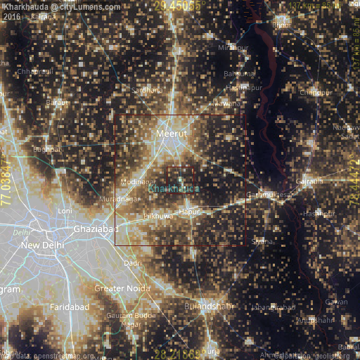
Analysis of Kharkhauda night lights 2016
Square area 10x10 km:
 0.19%
0.19%90-99
3.22%80-89
0%70-79
4.36%60-69
5.3%50-59
3.6%40-49
14.2%30-39
15.91%20-29
33.33%10-19
19.89%0-9
0%Square area 50x50 km:
4.27%90-99
9.23%80-89
10.02%70-79
6.07%60-69
8.24%50-59
9.74%40-49
10.71%30-39
10.1%20-29
11.75%10-19
16.5%0-9
3.37%Clear (daylight) street map image can be seen on geolist.org.
Map coordinates:
29° 27' 2" North, 77° 2' 18.5" East
28° 50' 11.2" North, 77° 44' 29.7" East
28° 13' 7.3" North, 78° 26' 41" East
Some cities around Kharkhauda sort by population:
• Meerut
16.3 km =10.1 mi,  347°
347°
• Hāpur
12.4 km =7.7 mi,  162°
162°
• Pilkhua
16.1 km =10 mi,  211°
211°
• Kithor
19.5 km =12.1 mi,  80°
80°
• Parīchhatgarh
24.5 km =15.2 mi,  49°
49°
• Farīdnagar
13.2 km =8.2 mi,  235°
235°
• Niwāri
20.3 km =12.6 mi,  282°
282°
• Babugarh
16.2 km =10.1 mi,  140°
140°
1266892 (p: 13,189)
Sources (retrieved 2019-11-25):
» Earth at Night: Flat Maps 2012, 2016