Mahābaleshwar night lights from space
Night Light of Mahābaleshwar (Maharashtra) from space (India) Src. Average luminocity for 10x10km area is 0.1219% and for 50x50km: 2.2874%.
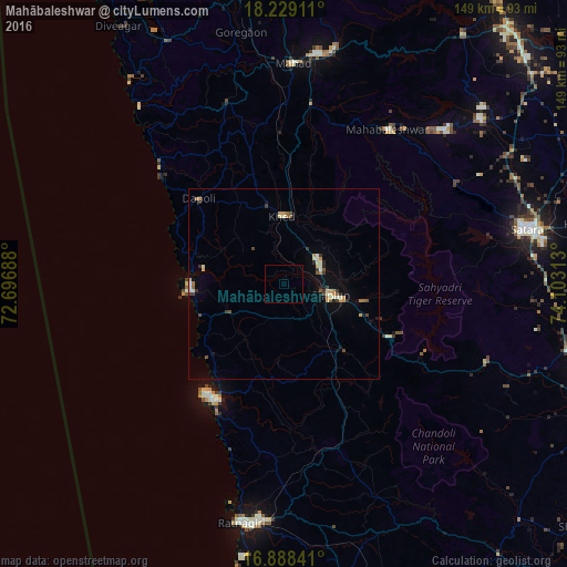
Analysis of Mahābaleshwar night lights 2016
Square area 10x10 km:
 0%
0%90-99
0%80-89
0%70-79
0%60-69
0%50-59
0%40-49
0%30-39
0%20-29
0%10-19
0%0-9
100%Square area 50x50 km:
0.04%90-99
0.49%80-89
0.23%70-79
0.41%60-69
0.24%50-59
0.32%40-49
0.28%30-39
0.44%20-29
0.24%10-19
0.72%0-9
96.6%Clear (daylight) street map image can be seen on geolist.org.
Map coordinates:
18° 13' 44.8" North, 72° 41' 48.8" East
17° 33' 36" North, 73° 24' 0" East
16° 53' 18.3" North, 74° 6' 11.3" East
Some cities around Mahābaleshwar sort by population:
• Chiplūn
12 km =7.5 mi,  104°
104°
• Koynanagar
42.8 km =26.6 mi,  114°
114°
• Khed
17.7 km =11 mi,  358°
358°
• Pātan
57 km =35.4 mi, 111°
• Mākhjan
34 km =21.1 mi,  161°
161°
• Dābhol
23.6 km =14.7 mi,  278°
278°
• Harnai
42.7 km =26.5 mi,  311°
311°
• Jalgaon
29.9 km =18.6 mi, 312°
1264491 (p: 13,598)
Sources (retrieved 2019-11-25):
» Earth at Night: Flat Maps 2012, 2016