Pātan night lights from space
Night Light of Pātan (Maharashtra) from space (India) Src. Average luminocity for 10x10km area is 2.4132% and for 50x50km: 1.7199%.
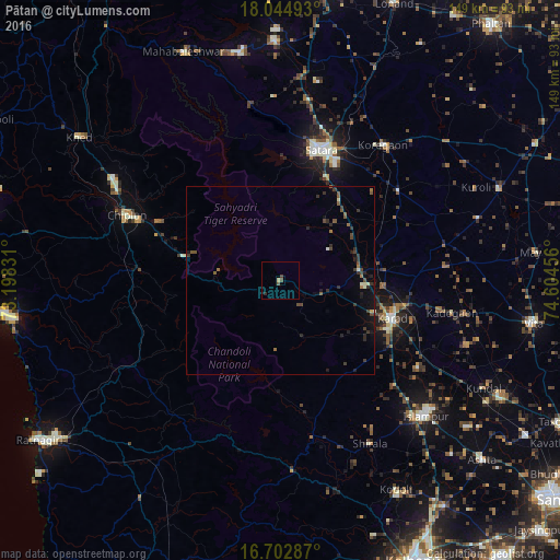
Analysis of Pātan night lights 2016
Square area 10x10 km:
 0%
0%90-99
0%80-89
0.83%70-79
0%60-69
0%50-59
1.24%40-49
1.24%30-39
0%20-29
0.83%10-19
0%0-9
95.87%Square area 50x50 km:
0%90-99
0.15%80-89
0.15%70-79
0.03%60-69
0.24%50-59
0.41%40-49
0.52%30-39
0.58%20-29
0.54%10-19
0.93%0-9
96.47%Clear (daylight) street map image can be seen on geolist.org.
Map coordinates:
18° 2' 41.7" North, 73° 11' 53.9" East
17° 22' 30.5" North, 73° 54' 5.1" East
16° 42' 10.3" North, 74° 36' 16.4" East
Some cities around Pātan sort by population:
• Satara
35.9 km =22.3 mi,  15°
15°
• Karād
31.3 km =19.4 mi,  107°
107°
• Chiplūn
45.2 km =28.1 mi,  292°
292°
• Malkapur
31.7 km =19.7 mi, 113°
• Koynanagar
14.6 km =9.1 mi,  280°
280°
• Rahimatpur
39.8 km =24.7 mi,  52°
52°
• Malkāpur
50.7 km =31.5 mi,  176°
176°
• Mākhjan
44.2 km =27.5 mi,  254°
254°
1260177 (p: 12,155)
Sources (retrieved 2019-11-25):
» Earth at Night: Flat Maps 2012, 2016