Kumbhrāj night lights from space
Night Light of Kumbhrāj (Madhya Pradesh) from space (India) Src. Average luminocity for 10x10km area is 12.8095% and for 50x50km: 9.6839%.
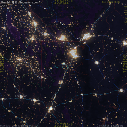
Analysis of Kumbhrāj night lights 2016
Square area 10x10 km:
 1.19%
1.19%90-99
1.98%80-89
0.6%70-79
0.2%60-69
2.18%50-59
2.18%40-49
2.78%30-39
0.79%20-29
3.57%10-19
2.38%0-9
82.14%Square area 50x50 km:
0.81%90-99
1.5%80-89
0.59%70-79
0.75%60-69
1.07%50-59
1.56%40-49
2.02%30-39
2.3%20-29
3.43%10-19
7.11%0-9
78.86%Clear (daylight) street map image can be seen on geolist.org.
Map coordinates:
25° 0' 44" North, 76° 20' 43" East
24° 22' 24.2" North, 77° 2' 54.3" East
23° 43' 52.7" North, 77° 45' 5.5" East
Some cities around Kumbhrāj sort by population:
• Guna
40.4 km =25.1 mi,  41°
41°
• Rāghogarh
17 km =10.6 mi,  62°
62°
• Rājgarh
51.7 km =32.1 mi,  218°
218°
• Chhabra
38.4 km =23.9 mi,  327°
327°
• Āron
37.4 km =23.2 mi,  88°
88°
• Aklera
48.9 km =30.4 mi,  275°
275°
• Leteri
50.5 km =31.4 mi,  133°
133°
• Manohar Thāna
29.1 km =18.1 mi,  239°
239°
1265670 (p: 16,391)
Sources (retrieved 2019-11-25):
» Earth at Night: Flat Maps 2012, 2016