Manohar Thāna night lights from space
Night Light of Manohar Thāna (Rajasthan) from space (India) Src. Average luminocity for 10x10km area is 16.2708% and for 50x50km: 7.5833%.
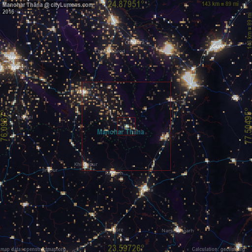
Analysis of Manohar Thāna night lights 2016
Square area 10x10 km:
 0.38%
0.38%90-99
2.46%80-89
1.7%70-79
0.76%60-69
1.52%50-59
3.03%40-49
4.92%30-39
4.55%20-29
3.79%10-19
5.11%0-9
71.78%Square area 50x50 km:
0.31%90-99
0.7%80-89
0.53%70-79
0.5%60-69
1.07%50-59
1.69%40-49
1.9%30-39
1.69%20-29
2.2%10-19
5.74%0-9
83.69%Clear (daylight) street map image can be seen on geolist.org.
Map coordinates:
24° 52' 46.2" North, 76° 5' 55.3" East
24° 14' 24" North, 76° 48' 6.6" East
23° 35' 50.1" North, 77° 30' 17.8" East
Some cities around Manohar Thāna sort by population:
• Rāghogarh
46 km =28.6 mi,  60°
60°
• Biaora
37.2 km =23.1 mi,  162°
162°
• Rājgarh
26.7 km =16.6 mi,  195°
195°
• Chhabra
47.4 km =29.5 mi,  5°
5°
• Aklera
30.6 km =19 mi,  308°
308°
• Khilchipur
31.8 km =19.8 mi,  225°
225°
• Kumbhrāj
29.1 km =18.1 mi, 59°
• Māchalpur
50.8 km =31.6 mi,  255°
255°
1263648 (p: 10,100)
Sources (retrieved 2019-11-25):
» Earth at Night: Flat Maps 2012, 2016