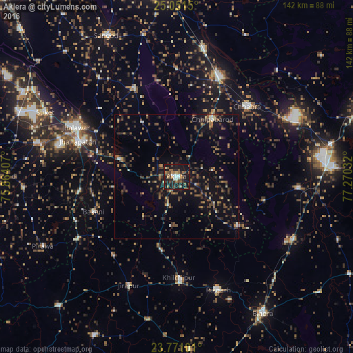
Aklera night lights from space
Night Light of Aklera (Rajasthan) from space (India) Src. Average luminocity for 10x10km area is 36.2639% and for 50x50km: 10.938%.
Analysis of Aklera night lights 2016
Square area 10x10 km:
 3.37%
3.37%90-99
4.76%80-89
1.39%70-79
4.96%60-69
6.75%50-59
7.34%40-49
9.13%30-39
4.17%20-29
12.3%10-19
44.84%0-9
0.99%Square area 50x50 km:
0.28%90-99
0.71%80-89
0.75%70-79
1.14%60-69
1.51%50-59
2.33%40-49
2.92%30-39
2.6%20-29
3.02%10-19
9.63%0-9
75.11%Clear (daylight) street map image can be seen on geolist.org.
Map coordinates:
25° 3' 5.4" North, 75° 51' 50.7" East
24° 24' 46.4" North, 76° 34' 1.9" East
23° 46' 15.6" North, 77° 16' 13.2" East
Some cities around Aklera sort by population:
• Jhālāwār
45.5 km =28.3 mi,  296°
296°
• Jhālrapātan
42.5 km =26.4 mi,  289°
289°
• Chhabra
39.6 km =24.6 mi,  44°
44°
• Khilchipur
41.5 km =25.8 mi,  178°
178°
• Khānpur
39.5 km =24.5 mi,  334°
334°
• Manohar Thāna
30.6 km =19 mi,  128°
128°
• Bakāni
36.3 km =22.6 mi,  247°
247°
• Māchalpur
40.6 km =25.2 mi,  218°
218°
1279115 (p: 19,683)
Sources (retrieved 2019-11-25):
» Earth at Night: Flat Maps 2012, 2016