Kulpahār night lights from space
Night Light of Kulpahār (Uttar Pradesh) from space (India) Src. Average luminocity for 10x10km area is 7.746% and for 50x50km: 5.0402%.
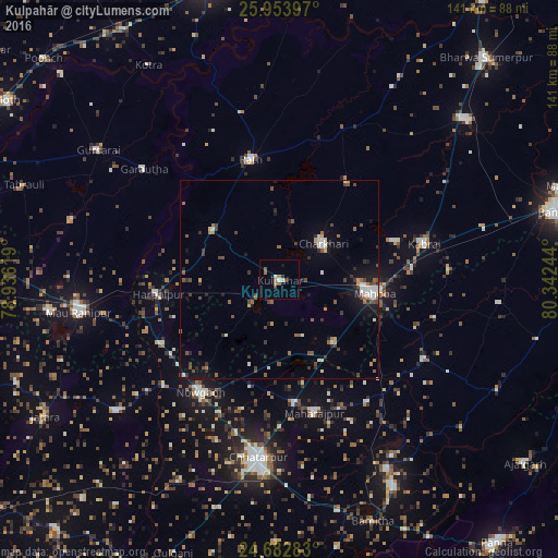
Analysis of Kulpahār night lights 2016
Square area 10x10 km:
 0.4%
0.4%90-99
1.19%80-89
0.79%70-79
0%60-69
2.98%50-59
0.99%40-49
1.79%30-39
0.79%20-29
0.6%10-19
1.59%0-9
88.89%Square area 50x50 km:
0.55%90-99
0.71%80-89
0.29%70-79
0.27%60-69
0.69%50-59
0.81%40-49
1.24%30-39
0.91%20-29
0.86%10-19
2.76%0-9
90.91%Clear (daylight) street map image can be seen on geolist.org.
Map coordinates:
25° 57' 14.3" North, 78° 56' 10.3" East
25° 19' 12.3" North, 79° 38' 21.5" East
24° 40' 58.2" North, 80° 20' 32.8" East
Some cities around Kulpahār sort by population:
• Mahobā
24 km =14.9 mi,  97°
97°
• Rāth
31.4 km =19.5 mi,  346°
346°
• Charkhāri
14.4 km =8.9 mi,  50°
50°
• Kabrāi
37.4 km =23.2 mi,  75°
75°
• Harpālpur
31 km =19.3 mi,  263°
263°
• Kharela
30.3 km =18.8 mi,  35°
35°
• Garautha
44.3 km =27.5 mi,  309°
309°
• Gohānd
43.1 km =26.8 mi, 347°
1265716 (p: 18,976)
Sources (retrieved 2019-11-25):
» Earth at Night: Flat Maps 2012, 2016