Charkhāri night lights from space
Night Light of Charkhāri (Uttar Pradesh) from space (India) Src. Average luminocity for 10x10km area is 17.0317% and for 50x50km: 5.5176%.
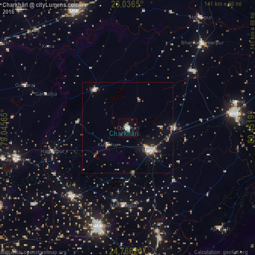

Analysis of Charkhāri night lights 2016
Square area 10x10 km:
 1.98%
1.98%90-99
4.96%80-89
1.79%70-79
1.59%60-69
1.59%50-59
0.79%40-49
1.98%30-39
0.79%20-29
2.78%10-19
4.37%0-9
77.38%Square area 50x50 km:
0.62%90-99
0.84%80-89
0.33%70-79
0.4%60-69
0.72%50-59
0.83%40-49
1.19%30-39
0.72%20-29
1.07%10-19
3.82%0-9
89.46%Clear (daylight) street map image can be seen on geolist.org.
Map coordinates:
26° 2' 11.4" North, 79° 2' 44.3" East
25° 24' 10.9" North, 79° 44' 55.6" East
24° 45' 58.5" North, 80° 27' 6.8" East
Some cities around Charkhāri sort by population:
• Mahobā
17.8 km =11.1 mi,  134°
134°
• Rāth
28.1 km =17.5 mi,  319°
319°
• Kabrāi
25.2 km =15.7 mi,  90°
90°
• Kulpahār
14.4 km =8.9 mi,  230°
230°
• Kharela
16.8 km =10.4 mi,  22°
22°
• Mataundh
41.1 km =25.5 mi,  84°
84°
• Sarīla
42.1 km =26.2 mi,  349°
349°
• Gohānd
38.7 km =24 mi,  328°
328°
1274574 (p: 24,881)
Sources (retrieved 2019-11-25):
» Earth at Night: Flat Maps 2012, 2016