Harpālpur night lights from space
Night Light of Harpālpur (Madhya Pradesh) from space (India) Src. Average luminocity for 10x10km area is 15.9325% and for 50x50km: 6.39%.
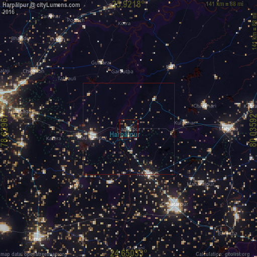
Analysis of Harpālpur night lights 2016
Square area 10x10 km:
 1.59%
1.59%90-99
0.79%80-89
1.59%70-79
0.79%60-69
2.18%50-59
2.78%40-49
2.98%30-39
6.55%20-29
4.17%10-19
4.56%0-9
72.02%Square area 50x50 km:
0.67%90-99
0.64%80-89
0.26%70-79
0.33%60-69
0.87%50-59
1.25%40-49
1.5%30-39
1.56%20-29
1.18%10-19
4.28%0-9
87.47%Clear (daylight) street map image can be seen on geolist.org.
Map coordinates:
25° 55' 18.5" North, 78° 37' 46.8" East
25° 17' 15.8" North, 79° 19' 58" East
24° 39' 1.2" North, 80° 2' 9.3" East
Some cities around Harpālpur sort by population:
• Rāth
41.4 km =25.7 mi,  34°
34°
• Gursarāi
39.7 km =24.7 mi,  337°
337°
• Kulpahār
31 km =19.3 mi,  83°
83°
• Rānīpur
27.5 km =17.1 mi,  261°
261°
• Jatāra
42.1 km =26.2 mi,  222°
222°
• Palera
31.6 km =19.6 mi,  199°
199°
• Tori-Fatehpur
28.8 km =17.9 mi,  310°
310°
• Garautha
31.8 km =19.8 mi,  353°
353°
1270291 (p: 17,731)
Sources (retrieved 2019-11-25):
» Earth at Night: Flat Maps 2012, 2016