Kheri Sāmpla night lights from space
Night Light of Kheri Sāmpla (Haryana) from space (India) Src. Average luminocity for 10x10km area is 25.553% and for 50x50km: 27.968%.
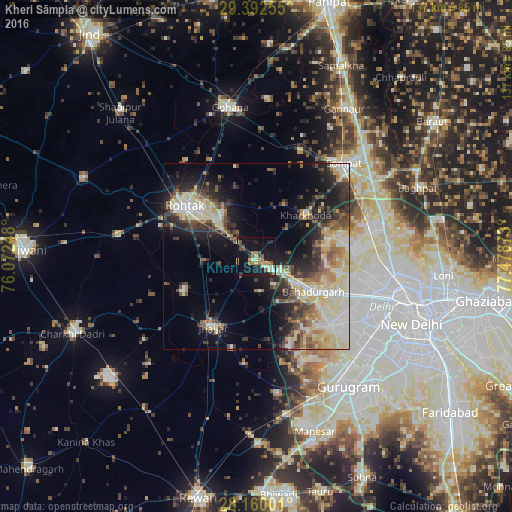
Analysis of Kheri Sāmpla night lights 2016
Square area 10x10 km:
 0.19%
0.19%90-99
3.98%80-89
2.84%70-79
4.17%60-69
4.55%50-59
4.55%40-49
5.11%30-39
2.65%20-29
3.98%10-19
31.44%0-9
36.55%Square area 50x50 km:
3.64%90-99
5.6%80-89
6.26%70-79
2.43%60-69
2.96%50-59
3.7%40-49
4.03%30-39
4.73%20-29
6.83%10-19
11.78%0-9
48.03%Clear (daylight) street map image can be seen on geolist.org.
Map coordinates:
29° 23' 33.2" North, 76° 4' 20.9" East
28° 46' 41.2" North, 76° 46' 32.2" East
28° 9' 36" North, 77° 28' 43.4" East
Some cities around Kheri Sāmpla sort by population:
• Najafgarh
27.4 km =17 mi,  133°
133°
• Rohini
28.7 km =17.8 mi,  97°
97°
• Rohtak
22.3 km =13.9 mi,  305°
305°
• Bahādurgarh
18.2 km =11.3 mi,  121°
121°
• Jhajjar
22.4 km =13.9 mi,  211°
211°
• Bawāna
25.3 km =15.7 mi,  84°
84°
• Kharkhauda
17.3 km =10.7 mi,  49°
49°
• Beri Khās
21.1 km =13.1 mi,  246°
246°
1436767 (p: 10,891)
Sources (retrieved 2019-11-25):
» Earth at Night: Flat Maps 2012, 2016