Beri Khās night lights from space
Night Light of Beri Khās (Haryana) from space (India) Src. Average luminocity for 10x10km area is 8.6875% and for 50x50km: 10.9667%.
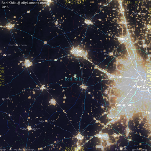
Analysis of Beri Khās night lights 2016
Square area 10x10 km:
 0.76%
0.76%90-99
1.52%80-89
0.76%70-79
0.57%60-69
0.95%50-59
1.14%40-49
3.22%30-39
0.95%20-29
1.52%10-19
0%0-9
88.64%Square area 50x50 km:
1.1%90-99
1.99%80-89
1.5%70-79
0.75%60-69
1.05%50-59
1.55%40-49
1.96%30-39
2.34%20-29
2.67%10-19
7.08%0-9
78%Clear (daylight) street map image can be seen on geolist.org.
Map coordinates:
29° 18' 58.9" North, 75° 52' 26.3" East
28° 42' 5.3" North, 76° 34' 37.5" East
28° 4' 58.5" North, 77° 16' 48.8" East
Some cities around Beri Khās sort by population:
• Rohtak
21.5 km =13.4 mi,  3°
3°
• Bahādurgarh
35 km =21.7 mi,  91°
91°
• Charkhi Dādri
32.2 km =20 mi,  247°
247°
• Jhajjar
13.1 km =8.1 mi,  143°
143°
• Kharkhauda
38 km =23.6 mi,  58°
58°
• Kalānaur
22.6 km =14 mi,  308°
308°
• Kheri Sāmpla
21.1 km =13.1 mi,  66°
66°
• Farrukhnagar
37.1 km =23.1 mi, 139°
1276437 (p: 16,727)
Sources (retrieved 2019-11-25):
» Earth at Night: Flat Maps 2012, 2016