Karīmpur night lights from space
Night Light of Karīmpur (West Bengal) from space (India) Src. Average luminocity for 10x10km area is 17.2576% and for 50x50km: 9.8762%.
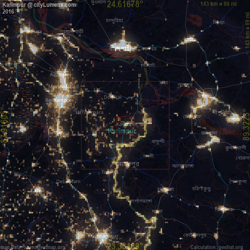
Analysis of Karīmpur night lights 2016
Square area 10x10 km:
 0%
0%90-99
0.57%80-89
1.7%70-79
0.76%60-69
0.19%50-59
3.03%40-49
7.58%30-39
9.09%20-29
6.63%10-19
9.66%0-9
60.8%Square area 50x50 km:
0.05%90-99
0.31%80-89
0.81%70-79
1.01%60-69
1.36%50-59
1.95%40-49
2.99%30-39
2.97%20-29
3.33%10-19
10.08%0-9
75.14%Clear (daylight) street map image can be seen on geolist.org.
Map coordinates:
24° 37' 0.4" North, 87° 54' 57.8" East
23° 58' 33.4" North, 88° 37' 9" East
23° 19' 54.8" North, 89° 19' 20.3" East
Some cities around Karīmpur sort by population:
• Rājshāhi, BD
44.3 km =27.5 mi,  357°
357°
• Baharampur
40 km =24.9 mi,  290°
290°
• Puthia, BD
48.5 km =30.1 mi,  26°
26°
• Ishurdi, BD
48.4 km =30.1 mi,  69°
69°
• Murshidābād
42.2 km =26.2 mi,  303°
303°
• Bherāmāra, BD
38.3 km =23.8 mi,  81°
81°
• Beldānga
36.8 km =22.9 mi,  262°
262°
• Debīpur
30.5 km =19 mi, 359°
1267754 (p: 9,565)
Sources (retrieved 2019-11-25):
» Earth at Night: Flat Maps 2012, 2016