Debīpur night lights from space
Night Light of Debīpur (West Bengal) from space (India) Src. Average luminocity for 10x10km area is 1.1193% and for 50x50km: 6.5771%.
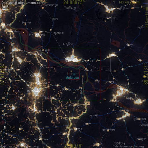
Analysis of Debīpur night lights 2016
Square area 10x10 km:
 0%
0%90-99
0%80-89
0%70-79
0%60-69
0%50-59
0%40-49
0.76%30-39
0%20-29
2.08%10-19
0.19%0-9
96.97%Square area 50x50 km:
0.65%90-99
1.18%80-89
0.4%70-79
0.36%60-69
0.49%50-59
0.76%40-49
1.19%30-39
1.85%20-29
3.05%10-19
4.24%0-9
85.81%Clear (daylight) street map image can be seen on geolist.org.
Map coordinates:
24° 53' 23.1" North, 87° 54' 54.4" East
24° 15' 1" North, 88° 37' 5.7" East
23° 36' 27.4" North, 89° 19' 16.9" East
Some cities around Debīpur sort by population:
• Rājshāhi, BD
13.9 km =8.6 mi,  352°
352°
• Natore, BD
41.4 km =25.7 mi,  64°
64°
• Baharampur
40.6 km =25.2 mi,  246°
246°
• Puthia, BD
25.4 km =15.8 mi, 59°
• Murshidābād
35.9 km =22.3 mi,  258°
258°
• Bherāmāra, BD
45.5 km =28.3 mi,  123°
123°
• Lālgola
41.7 km =25.9 mi,  297°
297°
• Karīmpur
30.5 km =19 mi,  179°
179°
1273347 (p: 9,613)
Sources (retrieved 2019-11-25):
» Earth at Night: Flat Maps 2012, 2016