Kāndri night lights from space
Night Light of Kāndri (Maharashtra) from space (India) Src. Average luminocity for 10x10km area is 28.6989% and for 50x50km: 14.7273%.
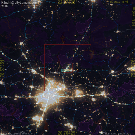
Analysis of Kāndri night lights 2016
Square area 10x10 km:
 1.89%
1.89%90-99
4.17%80-89
4.17%70-79
2.27%60-69
5.87%50-59
3.98%40-49
6.63%30-39
6.06%20-29
3.98%10-19
28.22%0-9
32.77%Square area 50x50 km:
2.31%90-99
2.68%80-89
1.7%70-79
1.93%60-69
1.69%50-59
2.13%40-49
2.37%30-39
2.33%20-29
3.3%10-19
7.93%0-9
71.62%Clear (daylight) street map image can be seen on geolist.org.
Map coordinates:
22° 4' 24.2" North, 78° 34' 24.6" East
21° 25' 13.1" North, 79° 16' 35.9" East
20° 45' 51.4" North, 79° 58' 47.1" East
Some cities around Kāndri sort by population:
• Nagpur
36.4 km =22.6 mi,  213°
213°
• Kāmthi
24.1 km =15 mi,  199°
199°
• Saoner
37 km =23 mi,  263°
263°
• Rāmtek
5.9 km =3.7 mi,  117°
117°
• Kalmeshwar
42.5 km =26.4 mi,  240°
240°
• Chicholi
44.3 km =27.5 mi,  82°
82°
• Khāpa
30.5 km =19 mi,  270°
270°
• Mansar
3 km =1.9 mi, 206°
1268114 (p: 8,315)
Sources (retrieved 2019-11-25):
» Earth at Night: Flat Maps 2012, 2016