Kalmeshwar night lights from space
Night Light of Kalmeshwar (Maharashtra) from space (India) Src. Average luminocity for 10x10km area is 25.2063% and for 50x50km: 29.247%.
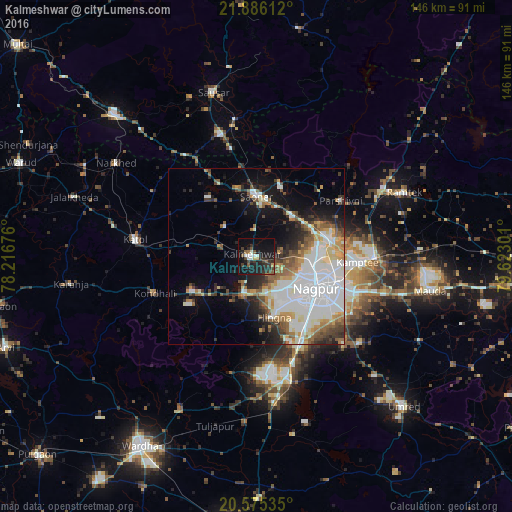
Analysis of Kalmeshwar night lights 2016
Square area 10x10 km:
 1.79%
1.79%90-99
4.56%80-89
0.79%70-79
1.59%60-69
0.79%50-59
5.16%40-49
3.77%30-39
7.94%20-29
12.9%10-19
34.33%0-9
26.39%Square area 50x50 km:
9.56%90-99
5.91%80-89
2.39%70-79
2.79%60-69
2.75%50-59
3.67%40-49
3.15%30-39
3.04%20-29
4.91%10-19
9.31%0-9
52.52%Clear (daylight) street map image can be seen on geolist.org.
Map coordinates:
21° 53' 10" North, 78° 13' 0.3" East
21° 13' 55.9" North, 78° 55' 11.6" East
20° 34' 31.3" North, 79° 37' 22.8" East
Some cities around Kalmeshwar sort by population:
• Nagpur
19.6 km =12.2 mi,  119°
119°
• Kāmthi
28.8 km =17.9 mi,  93°
93°
• Kātol
34.9 km =21.7 mi,  277°
277°
• Saoner
17 km =10.6 mi,  0°
0°
• Khāpa
22.1 km =13.7 mi,  16°
16°
• Lodhīkheda
39.4 km =24.5 mi,  350°
350°
• Mohpa
12.7 km =7.9 mi,  312°
312°
• Mansar
40 km =24.9 mi,  62°
62°
1268344 (p: 19,386)
Sources (retrieved 2019-11-25):
» Earth at Night: Flat Maps 2012, 2016