Iluppūr night lights from space
Night Light of Iluppūr (Tamil Nadu) from space (India) Src. Average luminocity for 10x10km area is 0.9752% and for 50x50km: 7.4124%.
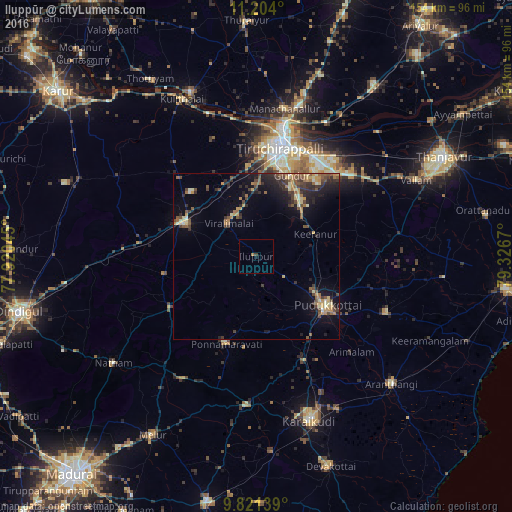
Analysis of Iluppūr night lights 2016
Square area 10x10 km:
 0%
0%90-99
0%80-89
0%70-79
0%60-69
0.83%50-59
0%40-49
0.21%30-39
0.62%20-29
0%10-19
0.41%0-9
97.93%Square area 50x50 km:
0%90-99
0.77%80-89
0.97%70-79
1.25%60-69
1.08%50-59
1.42%40-49
1.63%30-39
1.59%20-29
2.38%10-19
4.92%0-9
83.98%Clear (daylight) street map image can be seen on geolist.org.
Map coordinates:
11° 12' 14.4" North, 77° 55' 13.6" East
10° 30' 48.5" North, 78° 37' 24.9" East
9° 49' 17" North, 79° 19' 36.1" East
Some cities around Iluppūr sort by population:
• Tiruchirappalli
34.5 km =21.4 mi,  13°
13°
• Pudukkottai
26.2 km =16.3 mi,  124°
124°
• Manapparai
24 km =14.9 mi,  295°
295°
• Ponnamarāvati
27.6 km =17.1 mi,  200°
200°
• Puliyūr
27.3 km =17 mi,  60°
60°
• Kīranūr
18.9 km =11.7 mi,  70°
70°
• Arimalam
40.5 km =25.2 mi,  135°
135°
• Annavāsal
10.2 km =6.3 mi,  125°
125°
1269782 (p: 12,471)
Sources (retrieved 2019-11-25):
» Earth at Night: Flat Maps 2012, 2016