Annavāsal night lights from space
Night Light of Annavāsal (Tamil Nadu) from space (India) Src. Average luminocity for 10x10km area is 1.1694% and for 50x50km: 4.0193%.
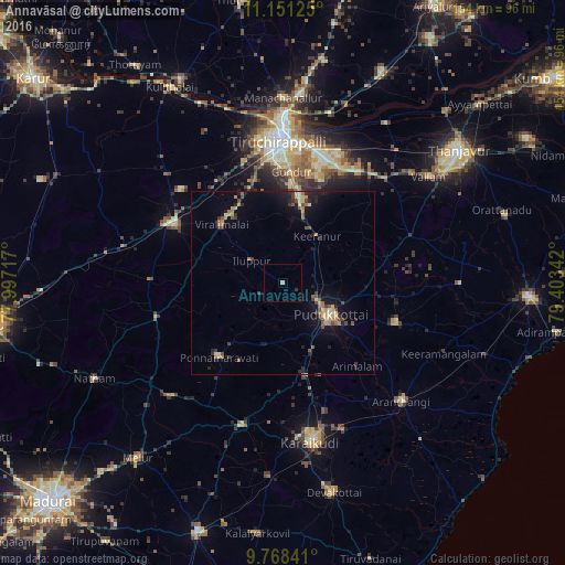
Analysis of Annavāsal night lights 2016
Square area 10x10 km:
 0%
0%90-99
0%80-89
0.83%70-79
0%60-69
0%50-59
0%40-49
0%30-39
0.83%20-29
0%10-19
0%0-9
98.35%Square area 50x50 km:
0%90-99
0.46%80-89
0.47%70-79
0.64%60-69
0.65%50-59
0.52%40-49
0.76%30-39
0.69%20-29
1.06%10-19
3.03%0-9
91.72%Clear (daylight) street map image can be seen on geolist.org.
Map coordinates:
11° 9' 4.5" North, 77° 59' 49.8" East
10° 27' 38.2" North, 78° 42' 1" East
9° 46' 6.3" North, 79° 24' 12.3" East
Some cities around Annavāsal sort by population:
• Pudukkottai
15.9 km =9.9 mi,  123°
123°
• Manapparai
34.2 km =21.3 mi,  298°
298°
• Iluppūr
10.2 km =6.3 mi,  305°
305°
• Ponnamarāvati
26.9 km =16.7 mi,  221°
221°
• Puliyūr
24.7 km =15.3 mi,  38°
38°
• Ālangudi
33.1 km =20.6 mi,  109°
109°
• Kīranūr
15.4 km =9.6 mi, 37°
• Arimalam
30.4 km =18.9 mi,  138°
138°
1278541 (p: 7,862)
Sources (retrieved 2019-11-25):
» Earth at Night: Flat Maps 2012, 2016