Kīranūr night lights from space
Night Light of Kīranūr (Tamil Nadu) from space (India) Src. Average luminocity for 10x10km area is 2.564% and for 50x50km: 12.8649%.
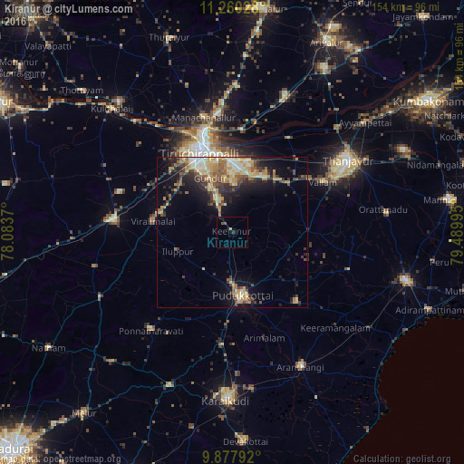
Analysis of Kīranūr night lights 2016
Square area 10x10 km:
 0%
0%90-99
0%80-89
0.21%70-79
0.62%60-69
0%50-59
0.62%40-49
1.03%30-39
0%20-29
0.83%10-19
2.07%0-9
94.63%Square area 50x50 km:
0.51%90-99
2.26%80-89
2.21%70-79
2.62%60-69
1.67%50-59
1.8%40-49
2.15%30-39
2.2%20-29
3.48%10-19
6.46%0-9
74.65%Clear (daylight) street map image can be seen on geolist.org.
Map coordinates:
11° 15' 37" North, 78° 5' 1.3" East
10° 34' 11.6" North, 78° 47' 12.6" East
9° 52' 40.5" North, 79° 29' 23.8" East
Some cities around Kīranūr sort by population:
• Tiruchirappalli
29 km =18 mi,  340°
340°
• Pudukkottai
21.3 km =13.2 mi,  169°
169°
• Lalgudi
34 km =21.1 mi,  5°
5°
• Vallam
34.2 km =21.3 mi,  60°
60°
• Iluppūr
18.9 km =11.7 mi,  250°
250°
• Puliyūr
9.3 km =5.8 mi,  40°
40°
• Ālangudi
31.8 km =19.8 mi,  137°
137°
• Annavāsal
15.4 km =9.6 mi,  217°
217°
1266513 (p: 10,133)
Sources (retrieved 2019-11-25):
» Earth at Night: Flat Maps 2012, 2016