Bilsanda night lights from space
Night Light of Bilsanda (Uttar Pradesh) from space (India) Src. Average luminocity for 10x10km area is 4.3512% and for 50x50km: 2.2684%.
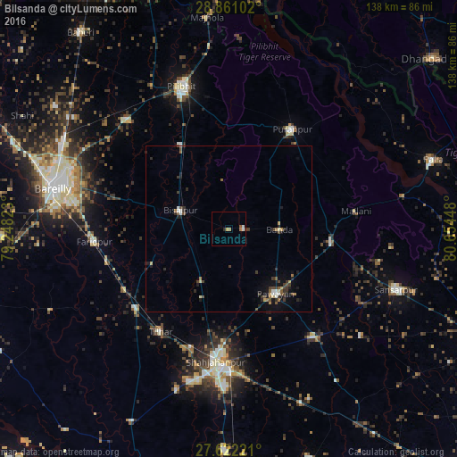
Analysis of Bilsanda night lights 2016
Square area 10x10 km:
 0.79%
0.79%90-99
0.79%80-89
0%70-79
0.79%60-69
1.59%50-59
0.6%40-49
0.2%30-39
0%20-29
0.79%10-19
0%0-9
94.44%Square area 50x50 km:
0.19%90-99
0.23%80-89
0.15%70-79
0.23%60-69
0.34%50-59
0.37%40-49
0.47%30-39
0.61%20-29
0.65%10-19
1.16%0-9
95.6%Clear (daylight) street map image can be seen on geolist.org.
Map coordinates:
28° 51' 39.7" North, 79° 14' 53.6" East
28° 14' 36.3" North, 79° 57' 4.9" East
27° 37' 20" North, 80° 39' 16.1" East
Some cities around Bilsanda sort by population:
• Bīsalpur
15.4 km =9.6 mi,  290°
290°
• Pūranpur
35.6 km =22.1 mi,  32°
32°
• Mīrānpur Katra
36.6 km =22.7 mi,  229°
229°
• Pawāyan
24.7 km =15.3 mi,  142°
142°
• Khūtār
31.6 km =19.6 mi,  98°
98°
• Khudāganj
25.6 km =15.9 mi,  244°
244°
• Barkhera Kalān
27.2 km =16.9 mi,  328°
328°
• Mohanpur
28.8 km =17.9 mi,  87°
87°
1275593 (p: 15,538)
Sources (retrieved 2019-11-25):
» Earth at Night: Flat Maps 2012, 2016