Barkhera Kalān night lights from space
Night Light of Barkhera Kalān (Uttar Pradesh) from space (India) Src. Average luminocity for 10x10km area is 4.9742% and for 50x50km: 3.9775%.
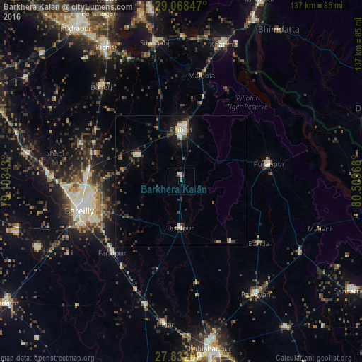
Analysis of Barkhera Kalān night lights 2016
Square area 10x10 km:
 1.39%
1.39%90-99
0.99%80-89
0%70-79
0%60-69
0.6%50-59
1.39%40-49
0.4%30-39
0.79%20-29
0.6%10-19
1.39%0-9
92.46%Square area 50x50 km:
0.44%90-99
0.47%80-89
0.35%70-79
0.17%60-69
0.34%50-59
0.53%40-49
0.89%30-39
1.05%20-29
1.23%10-19
2.6%0-9
91.92%Clear (daylight) street map image can be seen on geolist.org.
Map coordinates:
29° 4' 6.5" North, 79° 6' 12.3" East
28° 27' 7.5" North, 79° 48' 23.6" East
27° 49' 55.5" North, 80° 30' 34.8" East
Some cities around Barkhera Kalān sort by population:
• Pīlibhīt
19.9 km =12.4 mi,  359°
359°
• Bīsalpur
17.7 km =11 mi,  180°
180°
• Pūranpur
34.1 km =21.2 mi,  78°
78°
• Nawābganj
19.5 km =12.1 mi,  300°
300°
• Bilsanda
27.2 km =16.9 mi,  148°
148°
• Jahānābād
21.6 km =13.4 mi,  336°
336°
• Khudāganj
35.2 km =21.9 mi,  194°
194°
• Kālīnagar
32.7 km =20.3 mi,  55°
55°
1276922 (p: 11,209)
Sources (retrieved 2019-11-25):
» Earth at Night: Flat Maps 2012, 2016