Khūtār night lights from space
Night Light of Khūtār (Uttar Pradesh) from space (India) Src. Average luminocity for 10x10km area is 6.5734% and for 50x50km: 4.0842%.
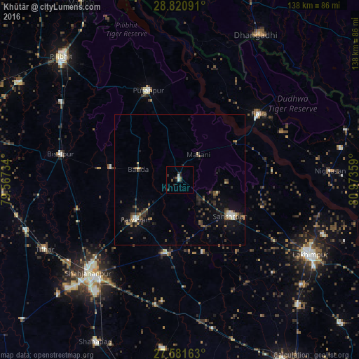
Analysis of Khūtār night lights 2016
Square area 10x10 km:
 1.19%
1.19%90-99
1.19%80-89
0%70-79
0%60-69
0.79%50-59
0.79%40-49
1.59%30-39
1.59%20-29
3.77%10-19
0.99%0-9
88.1%Square area 50x50 km:
0.23%90-99
0.38%80-89
0.28%70-79
0.26%60-69
0.48%50-59
0.73%40-49
0.89%30-39
1.26%20-29
1.31%10-19
2.83%0-9
91.34%Clear (daylight) street map image can be seen on geolist.org.
Map coordinates:
28° 49' 15.3" North, 79° 34' 2.4" East
28° 12' 11.1" North, 80° 16' 13.7" East
27° 34' 53.9" North, 80° 58' 24.9" East
Some cities around Khūtār sort by population:
• Bīsalpur
46.7 km =29 mi,  282°
282°
• Gola Gokarannāth
24 km =14.9 mi,  125°
125°
• Pūranpur
36.5 km =22.7 mi,  340°
340°
• Paliā Kalān
39.7 km =24.7 mi,  50°
50°
• Pawāyan
22.4 km =13.9 mi,  227°
227°
• Bilsanda
31.6 km =19.6 mi, 278°
• Mailāni
12.1 km =7.5 mi,  36°
36°
• Mohanpur
6 km =3.7 mi, 335°
1266596 (p: 15,618)
Sources (retrieved 2019-11-25):
» Earth at Night: Flat Maps 2012, 2016