Khudāganj night lights from space
Night Light of Khudāganj (Uttar Pradesh) from space (India) Src. Average luminocity for 10x10km area is 1.9413% and for 50x50km: 5.9013%.
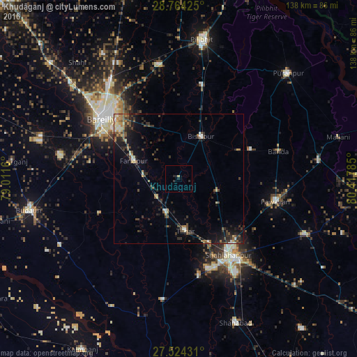
Analysis of Khudāganj night lights 2016
Square area 10x10 km:
 0%
0%90-99
0%80-89
0.76%70-79
0%60-69
0%50-59
0%40-49
0%30-39
0.95%20-29
1.33%10-19
1.89%0-9
95.08%Square area 50x50 km:
0.32%90-99
0.69%80-89
0.52%70-79
0.61%60-69
0.78%50-59
0.94%40-49
1.4%30-39
1.4%20-29
2.2%10-19
3.61%0-9
87.52%Clear (daylight) street map image can be seen on geolist.org.
Map coordinates:
28° 45' 51.3" North, 79° 0' 41.8" East
28° 8' 45.9" North, 79° 42' 53" East
27° 31' 27.5" North, 80° 25' 4.3" East
Some cities around Khudāganj sort by population:
• Shāhjānpur
35.1 km =21.8 mi,  147°
147°
• Farīdpur
18.4 km =11.4 mi,  292°
292°
• Bīsalpur
18.5 km =11.5 mi,  28°
28°
• Tilhar
20.5 km =12.7 mi,  173°
173°
• Mīrānpur Katra
13.7 km =8.5 mi,  199°
199°
• Dātāganj
32.9 km =20.4 mi,  245°
245°
• Bilsanda
25.6 km =15.9 mi,  64°
64°
• Barkhera Kalān
35.2 km =21.9 mi,  14°
14°
1266640 (p: 12,636)
Sources (retrieved 2019-11-25):
» Earth at Night: Flat Maps 2012, 2016