Amethi night lights from space
Night Light of Amethi (Uttar Pradesh) from space (India) Src. Average luminocity for 10x10km area is 6.6383% and for 50x50km: 4.9271%.
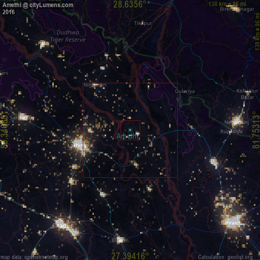
Analysis of Amethi night lights 2016
Square area 10x10 km:
 0.95%
0.95%90-99
0.57%80-89
0%70-79
1.14%60-69
0.76%50-59
1.14%40-49
0.76%30-39
1.89%20-29
1.89%10-19
5.3%0-9
85.61%Square area 50x50 km:
0.23%90-99
0.35%80-89
0.17%70-79
0.25%60-69
0.68%50-59
0.94%40-49
1.64%30-39
1.66%20-29
2.26%10-19
3.45%0-9
88.37%Clear (daylight) street map image can be seen on geolist.org.
Map coordinates:
28° 38' 8.2" North, 80° 20' 48.8" East
28° 1' 0" North, 81° 3' 0" East
27° 23' 39" North, 81° 45' 11.3" East
Some cities around Amethi sort by population:
• Lakhīmpur
27.6 km =17.1 mi,  254°
254°
• Nepalgunj, NP
55.7 km =34.6 mi,  86°
86°
• Lāharpur
37.2 km =23.1 mi,  202°
202°
• Gulariyā, NP
35.8 km =22.2 mi,  54°
54°
• Nānpāra
47.4 km =29.5 mi,  110°
110°
• Ṭikāpur, NP
57.3 km =35.6 mi,  6°
6°
• Kheri
27.8 km =17.3 mi,  243°
243°
• Dhaurahra
4.4 km =2.7 mi,  117°
117°
1278805 (p: 12,206)
Sources (retrieved 2019-11-25):
» Earth at Night: Flat Maps 2012, 2016