Ternate night lights from space
Night Light of Ternate (North Maluku) from space (Indonesia) Src. Average luminocity for 10x10km area is 25.0907% and for 50x50km: 1.5856%.
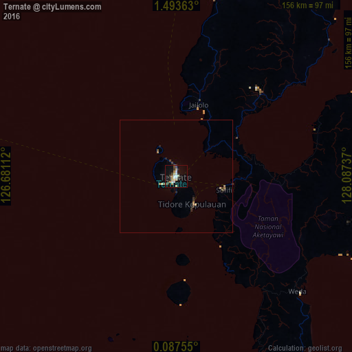
Analysis of Ternate night lights 2016
Square area 10x10 km:
 4.76%
4.76%90-99
3.4%80-89
4.54%70-79
3.85%60-69
0.68%50-59
1.36%40-49
3.4%30-39
5.22%20-29
0.91%10-19
21.32%0-9
50.57%Square area 50x50 km:
0.18%90-99
0.15%80-89
0.26%70-79
0.24%60-69
0.12%50-59
0.14%40-49
0.22%30-39
0.39%20-29
0.24%10-19
0.88%0-9
97.16%Clear (daylight) street map image can be seen on geolist.org.
Map coordinates:
1° 29' 37.1" North, 126° 40' 52" East
0° 47' 26.3" North, 127° 23' 3.3" East
0° 5' 15.2" North, 128° 5' 14.5" East
Some cities around Ternate sort by population:
• Manado
292.1 km =181.5 mi,  285°
285°
• Gorontalo
481.3 km =299.1 mi,  266°
266°
• Sorong
469.3 km =291.6 mi,  113°
113°
• Sofifi
20.3 km =12.6 mi, 106°
• Tondano
280.7 km =174.4 mi,  281°
281°
• Tomohon
292.8 km =181.9 mi, 281°
• Tobelo
125.3 km =77.9 mi,  33°
33°
• Laikit, Laikit II (Dimembe)
278.9 km =173.3 mi, 286°
1624041 (p: 101,731)
Sources (retrieved 2019-11-25):
» NASA, Earths city lights 1995
» NASA city lights 2003
» Earth at Night: Flat Maps 2012, 2016