Buaran night lights from space
Night Light of Buaran (Central Java) from space (Indonesia) Src. Average luminocity for 10x10km area is 4.7814% and for 50x50km: 7.8353%.
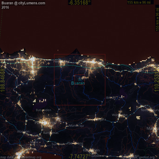

Analysis of Buaran night lights 2016
Square area 10x10 km:
 0%
0%90-99
0%80-89
0.65%70-79
1.08%60-69
0.65%50-59
0.22%40-49
3.46%30-39
0.87%20-29
0%10-19
1.08%0-9
91.99%Square area 50x50 km:
0.22%90-99
0.61%80-89
0.85%70-79
0.91%60-69
1.29%50-59
1.76%40-49
2.15%30-39
2.23%20-29
2.36%10-19
5.94%0-9
81.67%Clear (daylight) street map image can be seen on geolist.org.
Map coordinates:
6° 21' 6" South, 108° 50' 48.8" East
7° 3' 0" South, 109° 33' 0" East
7° 44' 50.2" South, 110° 15' 11.3" East
Some cities around Buaran sort by population:
• Pekalongan
22.7 km =14.1 mi,  37°
37°
• Pemalang
25.5 km =15.8 mi,  313°
313°
• Kedungwuni
14 km =8.7 mi,  50°
50°
• Purbalingga
42.8 km =26.6 mi,  208°
208°
• Comal
16.2 km =10.1 mi,  354°
354°
• Wiradesa
19.1 km =11.9 mi,  23°
23°
• Wonopringgo
10.4 km =6.5 mi, 44°
• Randudongkal
25.5 km =15.8 mi,  257°
257°
1647991 (p: 38,770)
Sources (retrieved 2019-11-25):
» Earth at Night: Flat Maps 2012, 2016