Santa María Chiquimula night lights from space
Night Light of Santa María Chiquimula (Totonicapán) from space (Guatemala) Src. Average luminocity for 10x10km area is 0.0847% and for 50x50km: 6.996%.
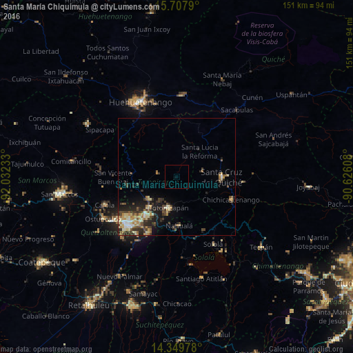
Analysis of Santa María Chiquimula night lights 2016
Square area 10x10 km:
 0%
0%90-99
0%80-89
0%70-79
0%60-69
0%50-59
0%40-49
0%30-39
0%20-29
0%10-19
0%0-9
100%Square area 50x50 km:
0.38%90-99
1.09%80-89
1.35%70-79
0.83%60-69
1.04%50-59
0.74%40-49
1.35%30-39
1.74%20-29
2.19%10-19
3.33%0-9
85.95%Clear (daylight) street map image can be seen on geolist.org.
Map coordinates:
15° 42' 28.4" North, 92° 1' 56.4" West
15° 1' 47.7" North, 91° 19' 45.1" West
14° 20' 59.2" North, 90° 37' 33.9" West
Some cities around Santa María Chiquimula sort by population:
• Chichicastenango
25.3 km =15.7 mi,  112°
112°
• Totonicapán
13.6 km =8.5 mi,  194°
194°
• San Francisco El Alto
15.5 km =9.6 mi,  232°
232°
• Momostenango
8.7 km =5.4 mi,  280°
280°
• Nahualá
20.8 km =12.9 mi,  176°
176°
• San Andrés Xecul
21.6 km =13.4 mi, 229°
• Salcajá
21.6 km =13.4 mi,  219°
219°
• San Carlos Sija
24.2 km =15 mi,  257°
257°
3589256 (p: 6,980)
Sources (retrieved 2019-11-25):
» Earth at Night: Flat Maps 2012, 2016