Momostenango night lights from space
Night Light of Momostenango (Totonicapán) from space (Guatemala) Src. Average luminocity for 10x10km area is 1.5496% and for 50x50km: 7.3685%.
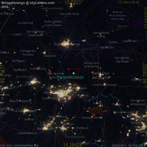
Analysis of Momostenango night lights 2016
Square area 10x10 km:
 0%
0%90-99
0%80-89
0%70-79
0.62%60-69
1.03%50-59
0%40-49
0%30-39
0.83%20-29
0%10-19
0%0-9
97.52%Square area 50x50 km:
0.37%90-99
1.17%80-89
1.32%70-79
0.77%60-69
1.01%50-59
0.83%40-49
1.36%30-39
1.98%20-29
2.57%10-19
4.66%0-9
83.97%Clear (daylight) street map image can be seen on geolist.org.
Map coordinates:
15° 43' 20.3" North, 92° 6' 42.4" West
15° 2' 39.7" North, 91° 24' 31.1" West
14° 21' 51.4" North, 90° 42' 19.9" West
Some cities around Momostenango sort by population:
• Totonicapán
15.6 km =9.7 mi,  160°
160°
• San Francisco El Alto
11.7 km =7.3 mi,  198°
198°
• Nahualá
24.4 km =15.2 mi, 156°
• San Andrés Xecul
17.5 km =10.9 mi,  207°
207°
• Salcajá
19 km =11.8 mi, 195°
• Huitán
24.8 km =15.4 mi,  271°
271°
• Santa María Chiquimula
8.7 km =5.4 mi,  100°
100°
• San Carlos Sija
16.5 km =10.3 mi,  246°
246°
3592483 (p: 31,739)
Sources (retrieved 2019-11-25):
» Earth at Night: Flat Maps 2012, 2016