Patulul night lights from space
Night Light of Patulul (Suchitepeque) from space (Guatemala) Src. Average luminocity for 10x10km area is 2.9048% and for 50x50km: 1.8667%.
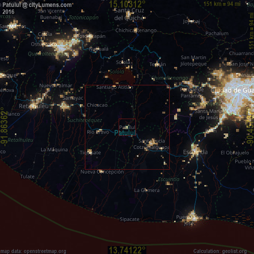
Analysis of Patulul night lights 2016
Square area 10x10 km:
 0%
0%90-99
0%80-89
0%70-79
0.87%60-69
0%50-59
0.87%40-49
0.87%30-39
1.73%20-29
1.73%10-19
0%0-9
93.94%Square area 50x50 km:
0.03%90-99
0.11%80-89
0.26%70-79
0.38%60-69
0.35%50-59
0.27%40-49
0.38%30-39
0.59%20-29
0.35%10-19
0.28%0-9
97.01%Clear (daylight) street map image can be seen on geolist.org.
Map coordinates:
15° 6' 11.2" North, 91° 51' 49" West
14° 25' 23.6" North, 91° 9' 37.8" West
13° 44' 28.4" North, 90° 27' 26.5" West
Some cities around Patulul sort by population:
• Santa Lucía Cotzumalguapa
17.7 km =11 mi,  123°
123°
• Santiago Atitlán
25 km =15.5 mi,  342°
342°
• Chicacao
22.3 km =13.9 mi,  306°
306°
• Tiquisate
26.6 km =16.5 mi,  234°
234°
• San Lucas Tolimán
19.1 km =11.9 mi,  4°
4°
• Santa Bárbara
7.3 km =4.5 mi,  280°
280°
• Yepocapa
23.9 km =14.9 mi,  68°
68°
• Río Bravo
17.1 km =10.6 mi,  261°
261°
3591541 (p: 14,196)
Sources (retrieved 2019-11-25):
» Earth at Night: Flat Maps 2012, 2016