San Lucas Tolimán night lights from space
Night Light of San Lucas Tolimán (Sololá) from space (Guatemala) Src. Average luminocity for 10x10km area is 0.829% and for 50x50km: 1.4077%.
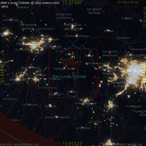
Analysis of San Lucas Tolimán night lights 2016
Square area 10x10 km:
 0%
0%90-99
0%80-89
0%70-79
0.87%60-69
0%50-59
0%40-49
0%30-39
0%20-29
0%10-19
0.43%0-9
98.7%Square area 50x50 km:
0%90-99
0.02%80-89
0.29%70-79
0.23%60-69
0.17%50-59
0.18%40-49
0.48%30-39
0.41%20-29
0.39%10-19
0.35%0-9
97.48%Clear (daylight) street map image can be seen on geolist.org.
Map coordinates:
15° 16' 26.7" North, 91° 50' 59" West
14° 35' 41" North, 91° 8' 47.7" West
13° 54' 47.7" North, 90° 26' 36.5" West
Some cities around San Lucas Tolimán sort by population:
• Sololá
20.1 km =12.5 mi,  348°
348°
• Santiago Atitlán
10.1 km =6.3 mi,  298°
298°
• Patzún
17.2 km =10.7 mi,  55°
55°
• Patulul
19.1 km =11.9 mi,  184°
184°
• Santa Bárbara
19.7 km =12.2 mi,  206°
206°
• Panajachel
16.4 km =10.2 mi,  356°
356°
• San Pedro La Laguna
17.4 km =10.8 mi,  308°
308°
• San Pablo La Laguna
19.5 km =12.1 mi,  316°
316°
3589850 (p: 14,545)
Sources (retrieved 2019-11-25):
» Earth at Night: Flat Maps 2012, 2016