Tiquisate night lights from space
Night Light of Tiquisate (Escuintla) from space (Guatemala) Src. Average luminocity for 10x10km area is 6.697% and for 50x50km: 0.8842%.
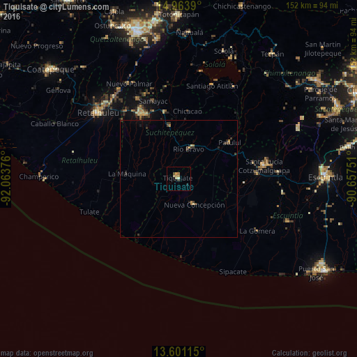
Analysis of Tiquisate night lights 2016
Square area 10x10 km:
 0%
0%90-99
0.87%80-89
1.73%70-79
2.16%60-69
1.3%50-59
0%40-49
0.87%30-39
0.87%20-29
0.65%10-19
0.22%0-9
91.34%Square area 50x50 km:
0%90-99
0.04%80-89
0.14%70-79
0.17%60-69
0.15%50-59
0.07%40-49
0.17%30-39
0.34%20-29
0.22%10-19
0.21%0-9
98.5%Clear (daylight) street map image can be seen on geolist.org.
Map coordinates:
14° 57' 50" North, 92° 3' 49.5" West
14° 17' 0.8" North, 91° 21' 38.3" West
13° 36' 4.1" North, 90° 39' 27" West
Some cities around Tiquisate sort by population:
• Chicacao
29.1 km =18.1 mi,  7°
7°
• Patulul
26.6 km =16.5 mi,  54°
54°
• Santa Bárbara
22.2 km =13.8 mi,  40°
40°
• Nueva Concepción
11.4 km =7.1 mi,  144°
144°
• San Antonio Suchitepéquez
29 km =18 mi,  348°
348°
• Río Bravo
13.8 km =8.6 mi,  19°
19°
• Santo Domingo Suchitepéquez
25.4 km =15.8 mi,  328°
328°
• San Bernardino
30.6 km =19 mi,  339°
339°
3591093 (p: 18,189)
Sources (retrieved 2019-11-25):
» Earth at Night: Flat Maps 2012, 2016